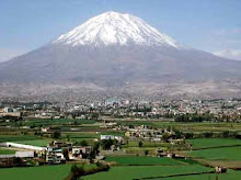
Arequipa is located in the southwestern part of the country and is the second biggest city of Peru, with a population of almost one million. It is the largest city in the Peruvian Andes. It is also the capital of the department of Arequipa, 663.8 miles (1,068 km) from Lima. The city sits at an altitude of 2,325 metres above sea level in a mountainous desert in the western Andes, at the foot of El Misti volcano. El Misti is currently inactive, but had strong eruptions between the years 1438 and 1471. It is located between two small volcanoes, Chachani and Picchu Picchu. Both names come from the Quechua language from the Inca Empire. Arequipa has more than 80 volcanoes, most of which can be found in the Valley of the Volcanoes. Unfortunately the city was built on a ver y earthquake prone area, and was completely destroyed by earthquakes and volcanic eruptions during the 1600’s. There is archaeological evidence of the Aymaras from the pre Inca period in Lake Titicaca. During the 15th century, the region occupied by the Aymaras was conquered by the Incas and served as an important provider of agricultural products for the Inca Empire. The Aymara named the city ‘ARI’ which means ‘peak’ and ‘QUIPA’, to lie behind. Therefore, the name Arequipa means ‘The place that lies behind the peak (Misti)’. The modern city of Arequipa was founded on
 August 15, 1540 by Garci Manuel de Carbajal, an emissary of the conqueror Francisco Pizarro. A year later King Charles V of Spain gave it the rank of city and the coat of arms that still remains.Arequipa
http://www.arequipaperu.org/
 y earthquake prone area, and was completely destroyed by earthquakes and volcanic eruptions during the 1600’s. There is archaeological evidence of the Aymaras from the pre Inca period in Lake Titicaca. During the 15th century, the region occupied by the Aymaras was conquered by the Incas and served as an important provider of agricultural products for the Inca Empire. The Aymara named the city ‘ARI’ which means ‘peak’ and ‘QUIPA’, to lie behind. Therefore, the name Arequipa means ‘The place that lies behind the peak (Misti)’. The modern city of Arequipa was founded on
 August 15, 1540 by Garci Manuel de Carbajal, an emissary of the conqueror Francisco Pizarro. A year later King Charles V of Spain gave it the rank of city and the coat of arms that still remains.Arequipa
http://www.arequipaperu.org/